Why would you want to know about Delaware Bay from a girl who lived almost all her life about 8500 miles away from it, a question you might ask? Is it because she is doing her MS based on this area? No, too weak reasoning. But bear with me, as I believe, when we see some outstanding things regularly, some magic gets lost. So, sometimes it’s better to learn about something from a person who themselves knew nothing about it.
Historically, Delaware Bay was inhabited by native americans Lenape people. Oh, I can give one fun fact about it, Delaware Bay was claimed by the Dutch East India company, who also claimed the Bengal region of India ( Modern day Bangladesh). There you go, I just found you a similarity between Delaware Bay and Bangladesh, now you should have faith in me.
I still remember the first day I saw the map of Delaware Bay. My advisor had drawn it in a small note. I thought it looked funny and cute. Such a nice and vivid funnel shape! That funnel shape is significant in my research, but more on that later.
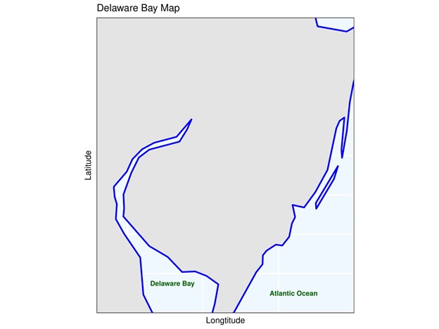
Figure: Map of Delaware Bay (My simple code to make this map can be find here:
Delaware Bay is the estuary outlet of the Delaware river. This river is the main tributary of Delaware Bay as approximately 50% of the total freshwater comes from it. This Bay is situated on the middle Atlantic coast of the United States.
The mouth of the Bay is around 18 km. Then the Bay widens up to 40 km and then it narrows in a funny cute funnel shape. Much of my research depends on this funnel shape, but more on this later. The mean depth of the Bay is 8 meters whereas the maximum depth is 45 meter. It has a deep channel and shallow flanks. Delaware Bay is a coastal plain estuary which means it was created when sea levels rise and fill in an existing river valley. This is why they are also called drowned river valleys.
Delaware Estuary has a surprisingly high tidal range (tidal range ~1.5 m). This is the main reason why much of the land along Delaware Bay is occupied by tidal marshes. Because of this high tidal range, all the ecosystems in the Delaware Estuary have to be adapted for a wide range of salinity.

Figure: Tidal range comparison between a station of Delaware bay (Ship John Shoal) and Chesapeake Bay (Chesapeake Channel, VA). From this figure it can be seen that compared to a station of Chesapeake Bay, how much higher the tidal range is in a station of Delaware Bay.
My code to make this can be find here : Github or my website
Because of this high tidal range, classification of Delaware Bay by salinity structure is not easy. It was previously thought to be a well mixed estuary. But the study done by María Aristizábal and Robert Chant shows that in the main channel there could be vertical stratification as high as 10 psu. The flanks of the Bay are well mixed. So in a nutshell, when there is spring tide, Delaware Bay behaves as a partially mixed estuary by demonstrating weak vertical stratification. However, when there is a neap tide, the bay shows strong vertical stratification. But if high river discharge takes place at the time of spring tide, Delaware Bay shows strong vertical stratification.
Naturally Bays are one of the most complex and productive habitats. The transition from the fresh water to the salt water creates a highly productive environment. Delaware Bay is home to a variety of species. It supports the largest population of HorseShoe crabs. It provides shelter for fish, shellfish and marine mammals. Alongside land of Delaware Bay is tidal wetland. Different vegetation types zones can be found throughout the tidal wetland. The low marsh of Delaware Bay is located along the seaward edge of the salt marsh. The main characteristic of low marsh is that it is usually flooded at every tide and exposed during low tide. It tends to occur as a narrow band along creeks and ditches. On the other hand, the high marsh is more expansive and is flooded less frequently. These salt marshes filter pollutants and sediments from the land. It provides protection from flooding and erosion.

Fig: Image source (ArcGIS) https://www.arcgis.com/home/webmap/viewer.html?webmap=a02346cf1db34b2eb5ea3b9976855bf4&extent=-76.5882,39.1226,-73.5999,40.9187
Here in the figure: Clear water is dark bluish, turbid water is cyan, grassland is pale green, forests dark green. To learn more about how to interpret images from GIS, click here.
Dredging of the main navigational channel of the Delaware Bay can disrupt the salt and sediment balance. It also disturbs the habitat of benthic species and coastal wetland. The upper reaches of Delaware Bay have been dredged since 1885. Even though the main purpose of dredging is to prevent the spread of contaminants to other areas of the water body, the net effect of this process is yet to be determined.
Sources:
- Aristizabal, M., and R. Chant (2013), A numerical study of salt fluxes in Delaware Bay estuary, J. Phys. Oceanogr., 43, 1572–1588.
- Beardsley, R. C., and W. C. Boicourt, 1981: On estuarine and continental-shelf circulation in the Middle Atlantic Bight. Evolution of Physical Oceanography, B. A. Warren and C. Wunsch, Eds., MIT Press, 198–233
- Bowen, M. M., 2000: Mechanisms and variability of salt transport in partially stratified estuaries. Ph.D. thesis
- Garvine, R. W., R. K. McCarthy, and K. C. Wong, 1992: The axial salinity distribution in the Delaware Estuary and its weak response to river discharge. Estuarine Coastal Shelf Sci., 35, 157–165
- Banas, N. S., B. M. Hickey, and P. MacCready, 2004: Dynamics of Willapa Bay, Washington: A highly unsteady, partially mixed estuary. J. Phys. Oceanogr., 34, 2413–2427